
A century ago, utilities were regularly being placed in the ground, yet it never seemed to catch on with anyone that the population would continue to grow, the number of buried utilities would continue to grow, and therefore there would be growing problems. Most utility owners kept records of what they were putting in the ground, but mainly to help them find the utility later on to perform any maintenance or repair, and those records were almost always nothing more than a large sheet of paper with hand-drawn lines.
However, what really made the situation a continually growing problem was the fact that there was no way to trace out the utility lines once they were buried. If you knew the utility was running along the north side of the road, well that’s about as good as you could get.
Today, there are 3 main groups involved in the marking and mapping of utilities. Let’s look at each one of them separately.
By the 1950’s the number of buried utilities was becoming a major problem for anyone excavating any new utilities – You tear out the phone cable while putting in the new power cable.
Yet, this was also the same decade when an electronic instrument now commonly known as a Pipe & Cable Locator was first becoming generally available. In the U.S. some states began including the phone numbers of the utility owners in the front pages of the phone book. If you were going to dig, then call each utility owner to see if they want to send someone out to mark any utility line they might have.
By the 1980’s some enterprising companies began offering their services to utility owners as specialized utility locators. These became the “contract locating firms”.
Gradually, each state formed a group to accept the phone calls from anyone performing excavation of any size. It might be a homeowner planting a tree, or a major contractor replacing a water pipe down Main Street, or even a utility owner doing work on their own plant., but all of them doing excavation.
Each state named their call centers by a different name; Sunshine One Call in Florida, or Idaho Dig Line in Idaho. There are some differences in their specific dig laws, but one thing they all have in common is that they are all call centers only. These One Call centers do not mark any utilities. Their purpose is to relay the excavator’s intent to the utility owners or their representatives.
There have been a few changes in the system over the years. Most One Call centers now accept online requests for marking. This speeds up the process and ensures that the information is documented as given because you documented it yourself.
One big addition to the One Call system was the 3-digit – 811 – number. Calling this number will get you in touch with the One Call center that is responsible for the area in which you are digging.
One Call locators typically mark the utilities according to the American Public Works Association (APWA) color code: red for electric, blue for water, orange for communications, etc. However, there are still some small areas of the country where the APWA color code is being ignored.

We are all familiar with the way new construction projects typically operate. First, we hear on the news that the road construction project will take nine months to complete and at a cost of eight million dollars. Then 14 months and 12 million dollars later, the project is still having problems.
There can be a variety of problems on any construction project but the number one cause of delays and increase in costs is from utilities. That gas main is four feet from where we thought it was, we were unaware of that communication manhole that was under a foot of gravel, and we thought that the only power lines were those aerial lines on the pole.
The problem does not begin with construction. It begins with the design engineers who have only poor information at their disposal. The utility prints are not updated, or they are wrong, or there is a utility line no one even knew about. The problems all come to light during construction, but they begin with poor information at the beginning of the project, during the design process.
The California High Speed Rail project is an excellent example of this. This was to be a 2-track system slated to run from Los Angeles to San Francisco by 2020 and at a cost of 33 billion. Instead, it has been dropped down to a one-track system, a projected cost of at least 100 billion, and the completion date is now somewhere between the year 2028 and infinity, and right now it looks much closer to infinity.
The problem can be summed up in three letters – S.U.E – because the California DOT did not use it on the project.
Subsurface Utility Engineering (SUE) had its origins in Virginia in the 1980’s. The purpose of SUE was to remove all of those surprises from highway projects. The basic idea is for the local DOT to hire an engineering firm to gather massive amounts of information on the project area, all of it relating to utility data. Don’t trust old outdated utility prints, don’t trust old utility marks, don’t trust anyone’s recollections of what is in the ground, frankly – don’t trust – investigate it yourself.
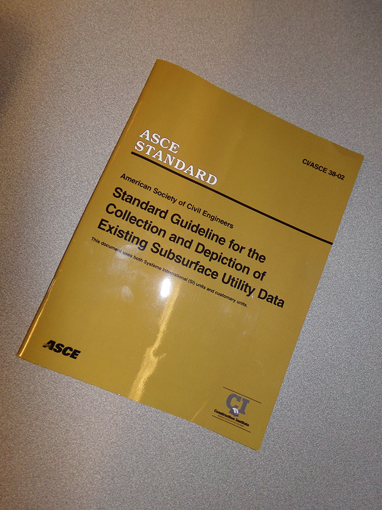
SUE projects are conducted by civil engineering firms, and obligated to abide by American Society of Civil Engineers (ASCE) document 38-02. They are required to use any and all of the latest geophysical instruments and practices to find every single type of utility in the ground, no matter who owns it, or whether or not it is indicated on the utility prints correctly. If it is there, then find it, mark it, map it, and relay that information to the design engineers.
This includes not only electric power, gas, water, and the usual, but also sanitary sewer and storm sewer. There are some disagreements on many areas that have not been specifically spelled out by ASCE 38-02. This includes traffic systems and irrigation systems, though most SUE firms do not map sprinklers.
The center point of SUE projects is on the Quality Levels. This is the real bedrock of any SUE project. Not only does each utility line need to be mapped, but each and every utility line must be labeled as to its Quality Level to indicate how much confidence the design engineers can put into designing around over or under each line. In some cases, a utility may simply need to be moved to make way for the change in the road and new changes to the drainage system, but the importance of SUE is to know for certain that the utility must be moved instead of assuming that it must be moved because of how it is indicated on the utility prints. If the pipe is four feet off the curb then it needs to be moved and at a lot of cost. But if it is four and a half feet off the curb then there will be just enough room to leave the pipe in place. So, the question is this – how do you know the pipe is four feet off the curb?
There are 4 Quality Levels to answer these questions: Quality Level A, B, C, and D. QLD indicates that the position of the utility line is vague coming only from old records or recollections.
QLC indicates a utility line where both ends of the utility are known, and that the utility should be running straight. This is most common with storm and sanitary pipes between manholes or other drainage structures.
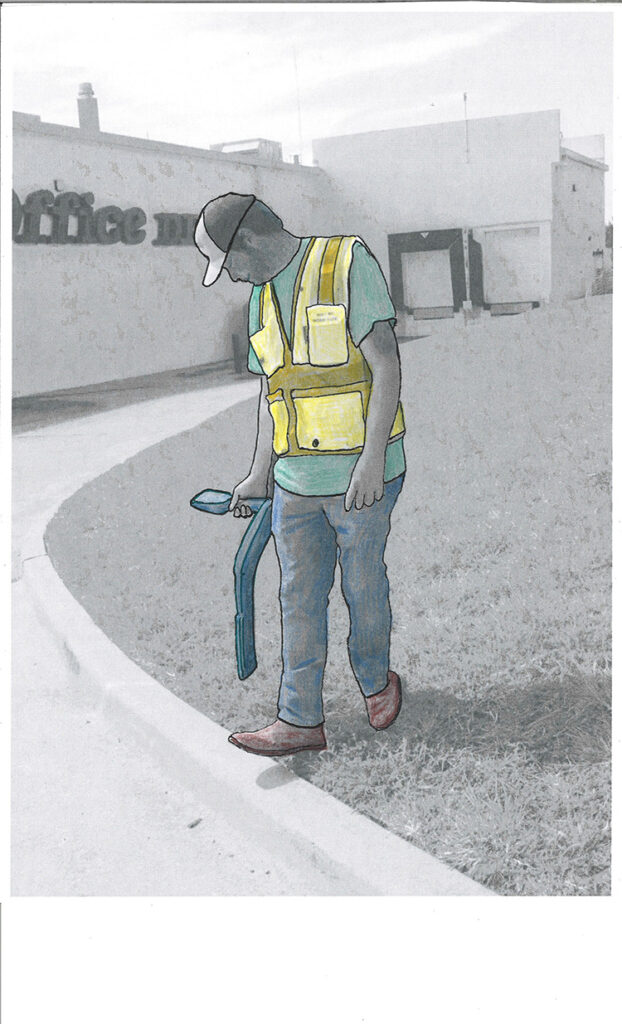
QLB is the most common, and indicates a utility line that has been traced out (designated) with an acceptable electronic geophysical instrument. This is most commonly a Pipe & Cable Locator, but may be Ground Penetrating Radar (GPR), a magnetometer, a P&C Locator used in conjunction with a rodder, a pipe inspection camera, a gradiometer, a sonde, or many other possibilities.
QLA indicates a utility line which can be visually observed so there is absolutely no question of the utility line’s position. As one can imagine that will usually only occur at specific points. You can see the end of a storm drain pipe looking down into a storm manhole – so that end of the storm pipe is QLA. This is not the entire storm pipe – only the end point of the pipe that is visible. This is also the reason why SUE projects typically involve vacuum truck excavation. The vac truck can expose any point along any pipe or cable, and once exposed and measured and surveyed, that single point now becomes QLA. How far is that pipe from the curb? It is four and a half feet. How do you know that? Because we exposed it with a vac truck at that point, and now there is no reason to move the pipe. A single vacuum truck test hole can save tens of thousands of dollars on the project. Some SUE projects may include hundreds of test holes – and save millions of dollars, and possibly tens of millions.
SUE become a common practice in one state after another, and it continues to grow. Many states today actually mandate SUE on every state road project, big or small. It saves a great deal of money and a great deal of time. It has been proven time and time again, and even investigated by groups such as Purdue University, and shown to be the most effective way to keep any DOT project on time and under budget. However, many states, such as California continue to ignore the practice, and are paying the price for it.
SUE is not mandated on a federal level, however it is strongly recommended by the U.S. Department of Transportation, and the American Society of Civil Engineers.
SUE firms tend to mark the utilities in a way that is usually quite noticeable. This is especially true with manholes of any kind and drainage inlets. These are numbered so the surveyor for the project can identify each and every manhole and drain inlet separately.
For the other utilities SUE firms often use pink paint, though many others use the standard APWA colors, though often putting the paint down in small dots or dashes instead of massive marks.
SUM projects are similar to SUE, but the big difference being that SUM projects do not fall under the guidance of the ASCE 38-02 standards. The standards of a SUM project are decided entirely by the client, whomever the client happens to be.
Many cities, counties, and especially private organizations feel that true SUE projects are too expensive. That is a very debatable point considering the decades of SUE projects and studies on SUE projects that show their overall cost savings time and time again. However, a SUE project comes before construction, so once the construction project begins to go bad, it is far too late to be calling in a SUE firm to “fix the project”. The project is either fixed beforehand, or not fixed at all. Just keep paying out more money as long as you can, and then cry to the feds to come bail you out.
Reasonable or not, many institutions want something less than SUE because this is an upfront cost. They want the utilities mapped, but they want to decide themselves what is important and what is not important in the mapping process. That in itself does not in any way mean that the project will be a disaster. A SUM firm can be just as diligent in their work as a SUE firm, in fact almost any SUE firm in existence is also regularly performing SUM projects as well simply because that is what the client wanted.
Originally many clients were reluctant to spend the money on any type of utility mapping, and many still are. Those that decided to “test the water” insisted that a full SUE process was too much. SUE firms were faced with either simplifying the process, or walking away from the project altogether. They decided to go with the client’s wishes and simplify the process, yet SUE firms still encourage clients to try SUE, sometimes with success, and sometimes not.
This gradually led to other engineering firms entering the utility mapping business, but specifically advertising themselves as a SUM firm, a utility mapping firm that adheres to whatever the client is looking for.
This may include ignoring the Quality Levels, or mapping only some utilities, slightly lowering the vertical accuracy of test hole, and in many cases performing only test holes without mapping the utilities first. In this case the cost is not actually going down but going up. If you have not carefully mapped out the utilities first, then doing test holes on them becomes a lengthy exercise in futility, and results in a large number of “dry holes”.
Although many cities and counties may use SUM, they are most common with private institutions such as industrial plants, airports, universities, shopping malls, trailer courts and hospitals.
How ever anyone feels about SUM, it is not going to go away. Some clients will continue to resist a full SUE project and demand only a SUM project, and someone is going to answer that call. It may be a SUM firm that prefers that type of project, or it may be a SUE firm that will take the project reluctantly, but it will get done.
Again, just because a project is a SUM project does not mean it is faulty in any way, only that the client themselves decided the extent of the mapping process.